Main Road Corridor Segment C
Public Information Meeting
APRIL-MAY 2022
This is the second public information meeting for Main Road Corridor, Segment C: Bohicket Road from Maybank Highway to Betsy Kerrison Parkway.
Charleston County is pleased to present six alternatives for consideration. All six of the reasonable alternatives presented meet the purpose of the project.
The project team invites you to review the proposed alternatives presented below and provide feedback. Please submit comments by filling out the form at the bottom of this page, or by clicking the Contact tab at the top of this page. Your comments will help the project team refine the alternatives and make a recommendation of a preferred alternative.
Project Purpose
The purpose of the project is to enhance traffic operations by reducing existing traffic congestion along the Main Road corridor while accommodating future traffic needs.
The primary purpose of the project is to:
- Reduce congestion (See projected traffic data.)
- Increase capacity on Main Road/Bohicket Road from Maybank Highway to Betsy Kerrison Parkway.
The secondary purpose of the project is to:
Provide opportunities for bicyclists and pedestrians to safely travel throughout the project area.
Project Background
Charleston County identified funding to improve Main Road in the 2016 Transportation Sales Tax ordinance. At that time, the ordinance listed the project as the US 17 at Main Road flyover and widening Main Road from Bees Ferry Road to Betsy Kerrison Parkway. In an effort to expedite improvements, the County has separated the project into three segments: Segment A, Segment B, and Segment C.
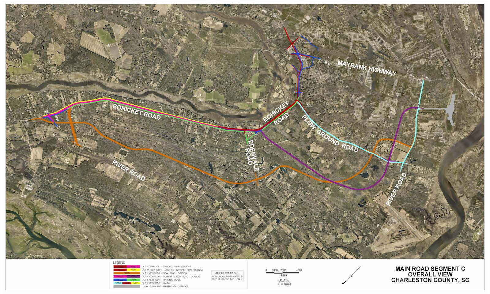
Segment C begins at the intersection of Bohicket Road and Maybank Highway and extends to Betsy Kerrison Parkway. The project team studied several options for the segment, including widening River Road, widening Bohicket Road, and constructing a new road across the island.
A video is being shown
Project Development Process
All federally aided projects and/or projects with the need for federal permitting must comply and adhere to the National Environmental Policy Act (NEPA). The NEPA process often takes three (3) to eight (8) years to complete, and requires the following to complete:
- Public input throughout
- Technical studies (18)
- Development of alternatives
- Analyze alternatives
- Development of a Preferred Alternative
- Preparation of a draft environmental assessment
- Revision of the preferred alternative
- US Army Corps of Engineers decision
Current Status
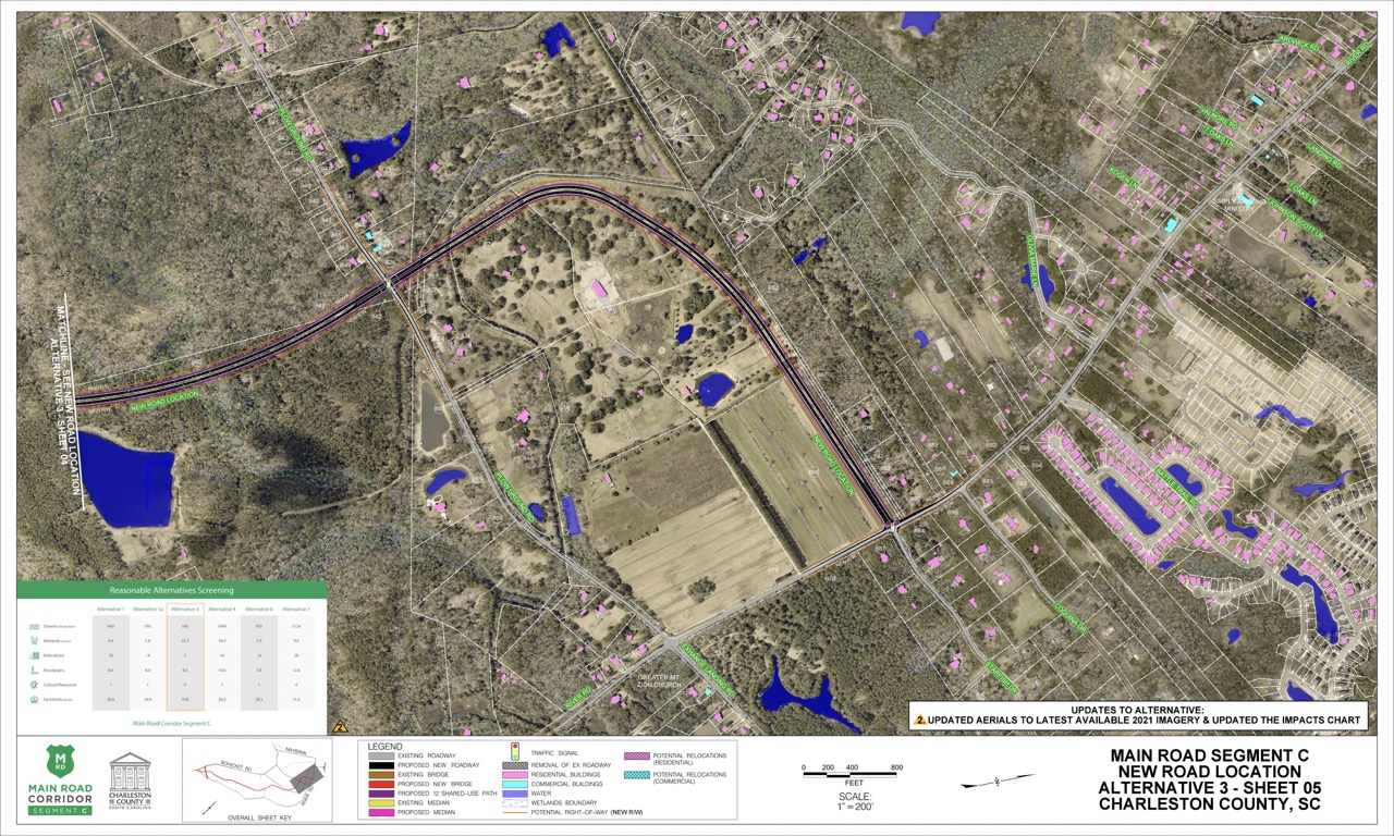
Charleston County initially identified five alternatives that meet the purpose and need of the project and presented these alternatives at an Online Public Information Meeting in October-Dec 2020. During the public comment period the public showed a desire for an in-person meeting and the County agreed to hold a second meeting once COVID-19 restrictions were lifted. During this period, public involvement was ongoing and additional alternatives were identified (Alternatives 1a, 6, and 7), and Alternative 2 and Alternative 5 were eliminated from further consideration due to extensive impacts. Six alternatives are being presented for public comment. All six alternatives meet the purpose and need of the project and have varying impacts to natural and human environments. The project team now needs your input on the presented alternatives.
Next Steps
Once the public comment period has ended, the design team will use your input, along with information gathered from preliminary environmental studies, to refine the project alternatives and identify a Preferred Alternative. Once selected, the County will present a Preferred Alternative, at which time the public will have another opportunity to ask questions and provide input on the project. The final design and right-of-way acquisition phase will begin following the second public comment period.


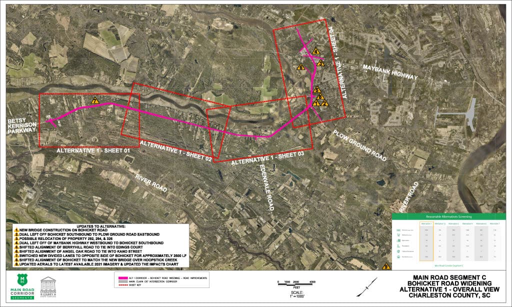
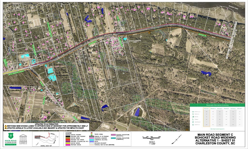
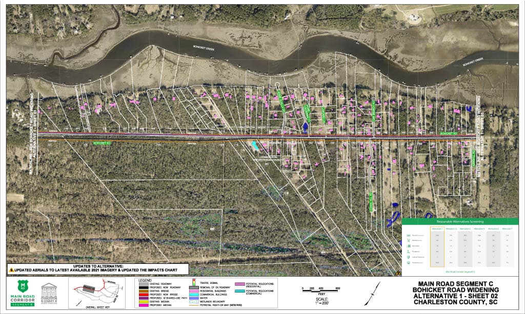
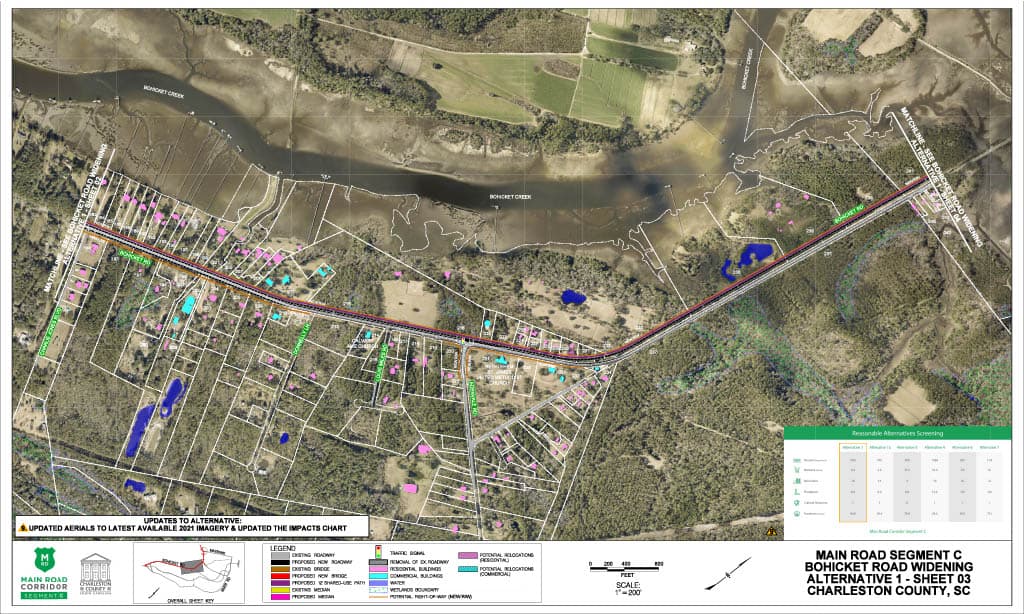
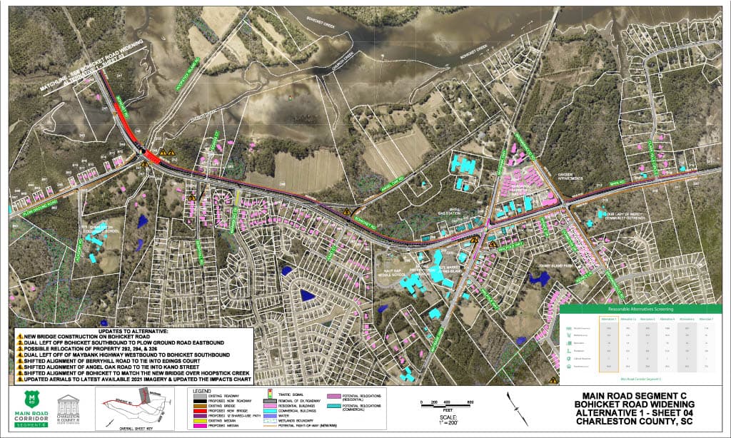
Alternative 1
Bohicket Road Widening ($120-$145 M)
Alternative 1 KMZ
This KMZ file works in the program Google Earth, and will allow you to view the entire alternative. The KMZ file is a more interactive option to viewing the alternatives. However, this option will not show the matrix comparing the alternatives or a legend.
DownloadWetland Impacts
Land permanently or seasonally covered with water is called a wetland. Wetlands are considered “waters of the United States” and are regulated under the Clean Water Act. The project team must identify all wetlands within the project area and avoid impacting them if possible. If an alternative meets the purpose of the project but cannot avoid impacts to a wetland, the County is required to minimize and mitigate impacts.
8.4 acres
Stream Impacts
Streams are considered “waters of the United States” and are regulated under the Clean Water Act. The project team must identify all streams within the project area and avoid them if possible. If an alternative meets the purpose of the project but cannot avoid impacts to streams, the County is required to minimize and mitigate impacts.
1461 linear feet
Potential Relocations
These are properties that may require relocation of the residence or business in order to construct the project. The project team must identify all potential property relocations within the project area and avoid them if possible. If an alternative meets the purpose of the project but cannot avoid property relocations, the County is required to follow the United States Uniform Relocation Assistance and Real Property Acquisition Policies Act of 1970, the South Carolina Eminent Domain Procedure Act, and SCDOT’s Right of Way Manuals.
18
Floodplain Impacts
Floodplains are areas next to streams or rivers which experience flooding when the water is high. The project team must comply with Executive Order 11988 and document efforts to avoid, minimize, and mitigate impacts to floodplains.
8 acres
Farmlands
Farmlands of statewide importance fall under the Farmland Protection Policy Act. These are farmlands that meet specific criteria based on the physical and chemical properties of the soils. Farmlands of statewide importance are identified by the Soil Conservation Service, and impacts must be documented in the environmental documentation.
of Statewide Significance
40.6 acres
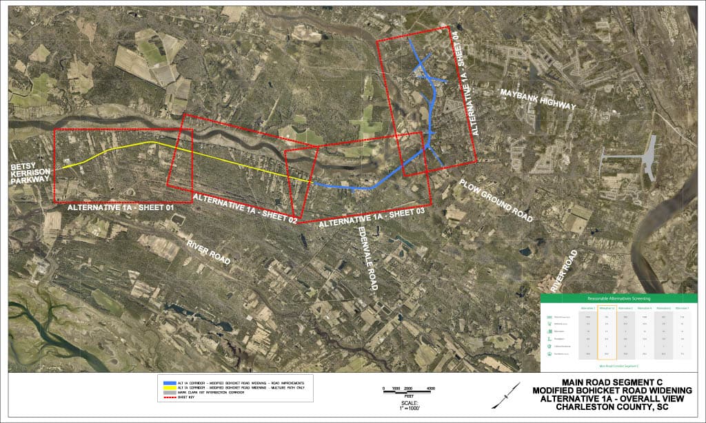
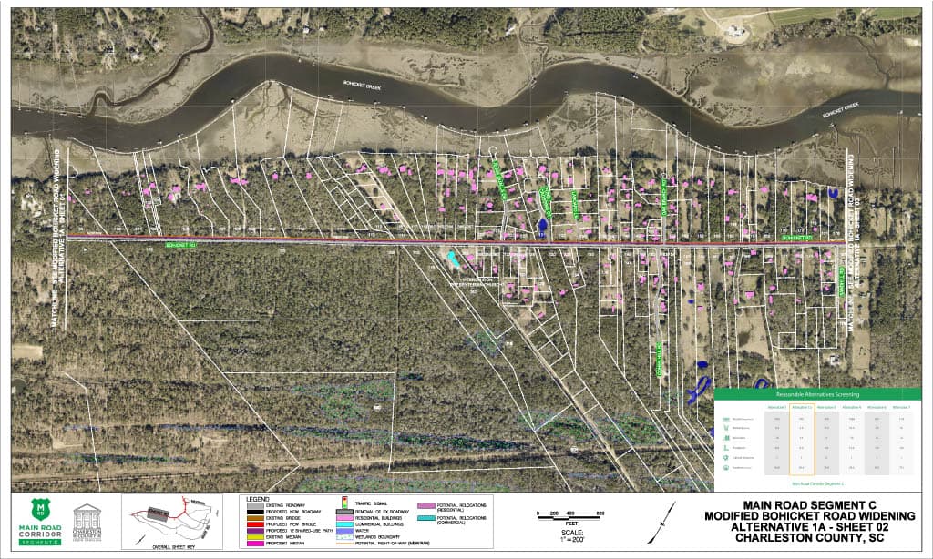
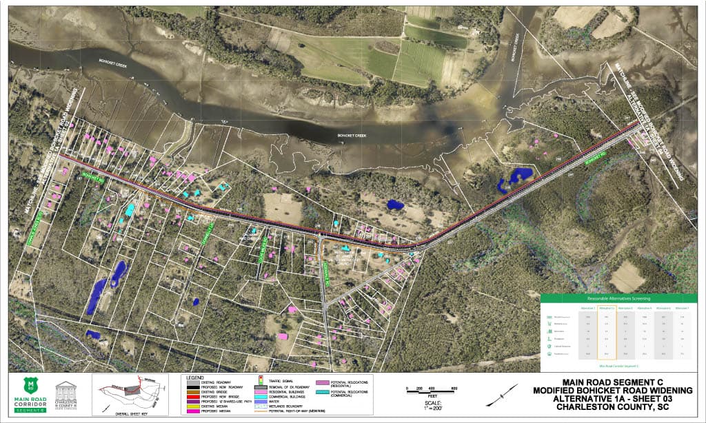
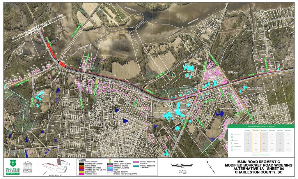
Alternative 1A
Modified Bohicket Road Widening ($65-$80 M)
Alternative 1A KMZ
This KMZ file works in the program Google Earth, and will allow you to view the entire alternative. The KMZ file is a more interactive option to viewing the alternatives. However, this option will not show the matrix comparing the alternatives or a legend.
DownloadWetland Impacts
Land permanently or seasonally covered with water is called a wetland. Wetlands are considered “waters of the United States” and are regulated under the Clean Water Act. The project team must identify all wetlands within the project area and avoid impacting them if possible. If an alternative meets the purpose of the project but cannot avoid impacts to a wetland, the County is required to minimize and mitigate impacts.
5.8 acres
Stream Impacts
Streams are considered “waters of the United States” and are regulated under the Clean Water Act. The project team must identify all streams within the project area and avoid them if possible. If an alternative meets the purpose of the project but cannot avoid impacts to streams, the County is required to minimize and mitigate impacts.
795 linear feet
Potential Relocations
These are properties that may require relocation of the residence or business in order to construct the project. The project team must identify all potential property relocations within the project area and avoid them if possible. If an alternative meets the purpose of the project but cannot avoid property relocations, the County is required to follow the United States Uniform Relocation Assistance and Real Property Acquisition Policies Act of 1970, the South Carolina Eminent Domain Procedure Act, and SCDOT’s Right of Way Manuals.
14
Floodplain Impacts
Floodplains are areas next to streams or rivers which experience flooding when the water is high. The project team must comply with Executive Order 11988 and document efforts to avoid, minimize, and mitigate impacts to floodplains.
8 acres
Farmlands
Farmlands of statewide importance fall under the Farmland Protection Policy Act. These are farmlands that meet specific criteria based on the physical and chemical properties of the soils. Farmlands of statewide importance are identified by the Soil Conservation Service, and impacts must be documented in the environmental documentation.
of Statewide Significance
29.6 acres

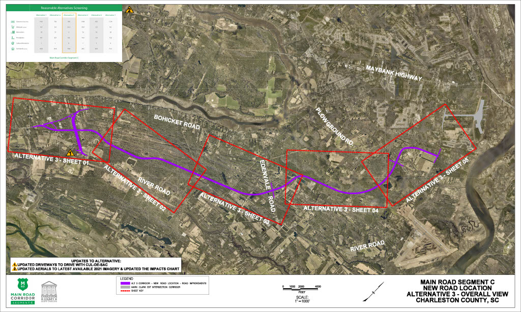
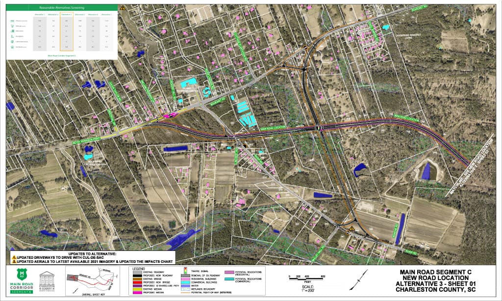
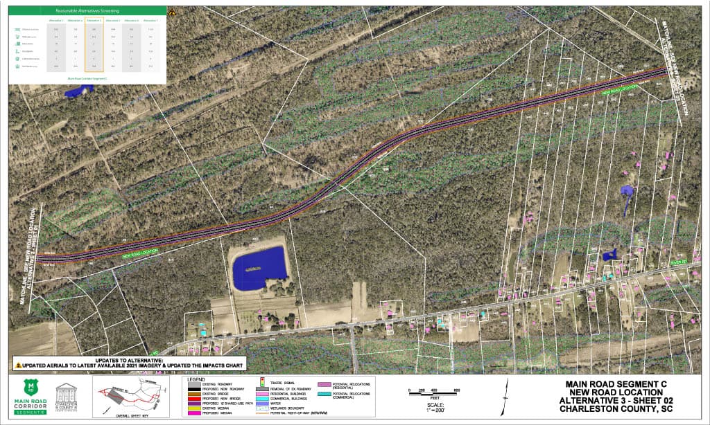
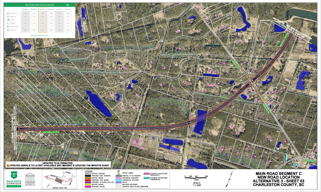
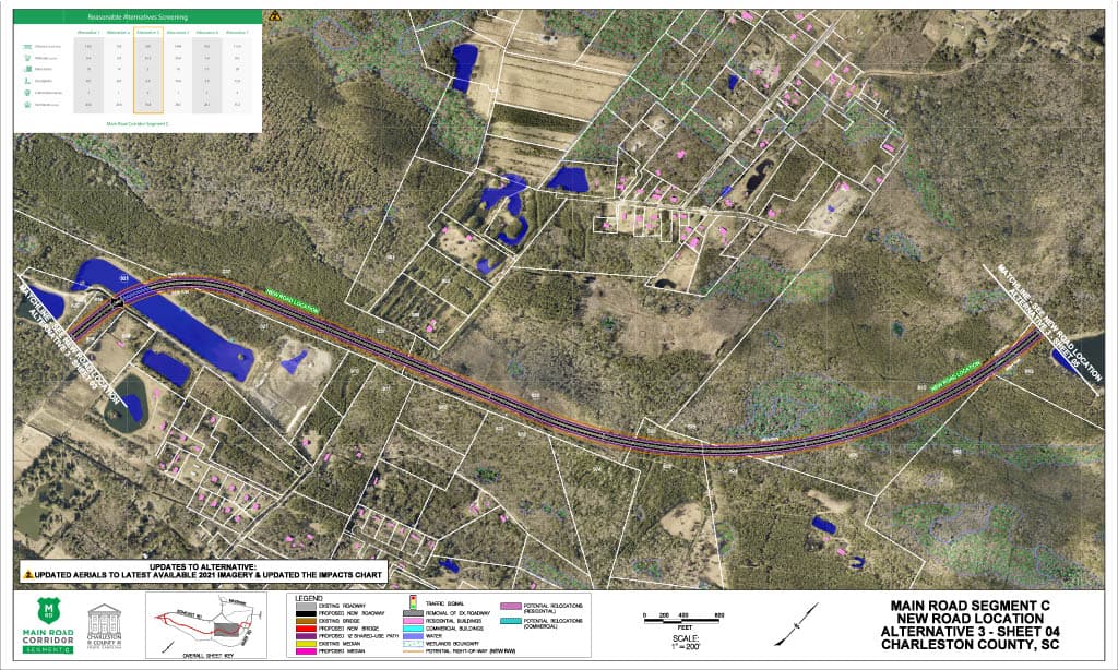
Alternative 3
New Road Location ($170-$195 M)
Alternative 3 KMZ
This KMZ file works in the program Google Earth, and will allow you to view the entire alternative. The KMZ file is a more interactive option to viewing the alternatives. However, this option will not show the matrix comparing the alternatives or a legend.
DownloadWetland Impacts
Land permanently or seasonally covered with water is called a wetland. Wetlands are considered “waters of the United States” and are regulated under the Clean Water Act. The project team must identify all wetlands within the project area and avoid impacting them if possible. If an alternative meets the purpose of the project but cannot avoid impacts to a wetland, the County is required to minimize and mitigate impacts.
35.3 acres
Stream Impacts
Streams are considered “waters of the United States” and are regulated under the Clean Water Act. The project team must identify all streams within the project area and avoid them if possible. If an alternative meets the purpose of the project but cannot avoid impacts to streams, the County is required to minimize and mitigate impacts.
590 linear feet
Potential Relocations
These are properties that may require relocation of the residence or business in order to construct the project. The project team must identify all potential property relocations within the project area and avoid them if possible. If an alternative meets the purpose of the project but cannot avoid property relocations, the County is required to follow the United States Uniform Relocation Assistance and Real Property Acquisition Policies Act of 1970, the South Carolina Eminent Domain Procedure Act, and SCDOT’s Right of Way Manuals.
2
Floodplain Impacts
Floodplains are areas next to streams or rivers which experience flooding when the water is high. The project team must comply with Executive Order 11988 and document efforts to avoid, minimize, and mitigate impacts to floodplains.
8.8 acres
Farmlands
Farmlands of statewide importance fall under the Farmland Protection Policy Act. These are farmlands that meet specific criteria based on the physical and chemical properties of the soils. Farmlands of statewide importance are identified by the Soil Conservation Service, and impacts must be documented in the environmental documentation.
of Statewide Significance
79.8 acres
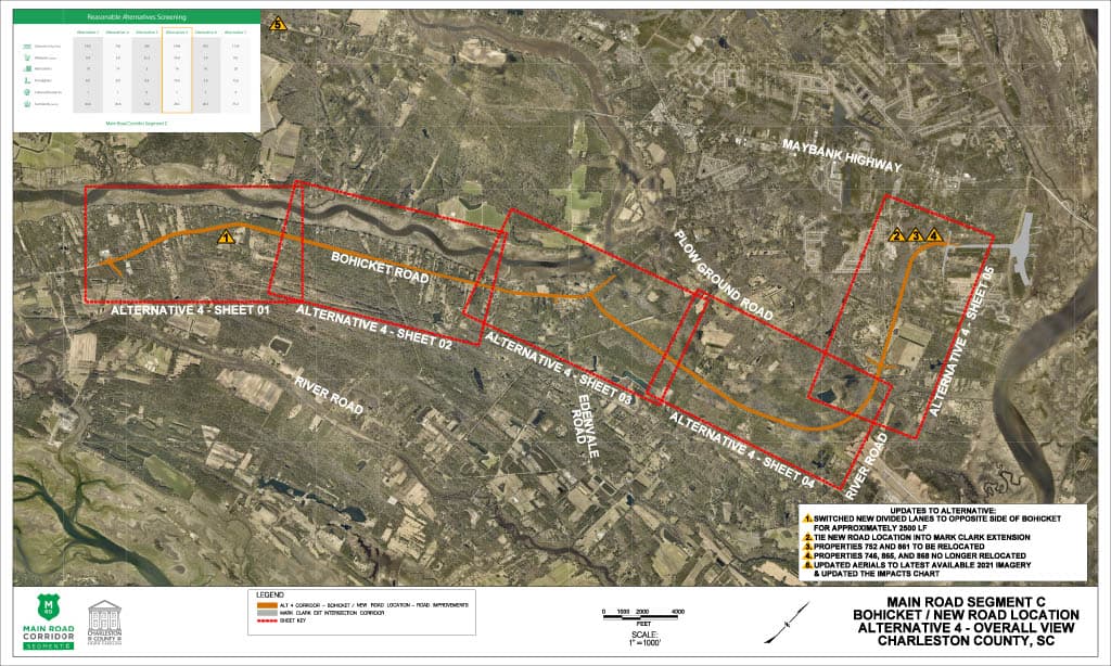
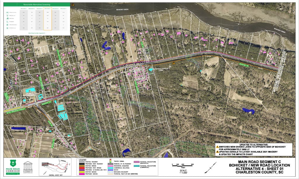
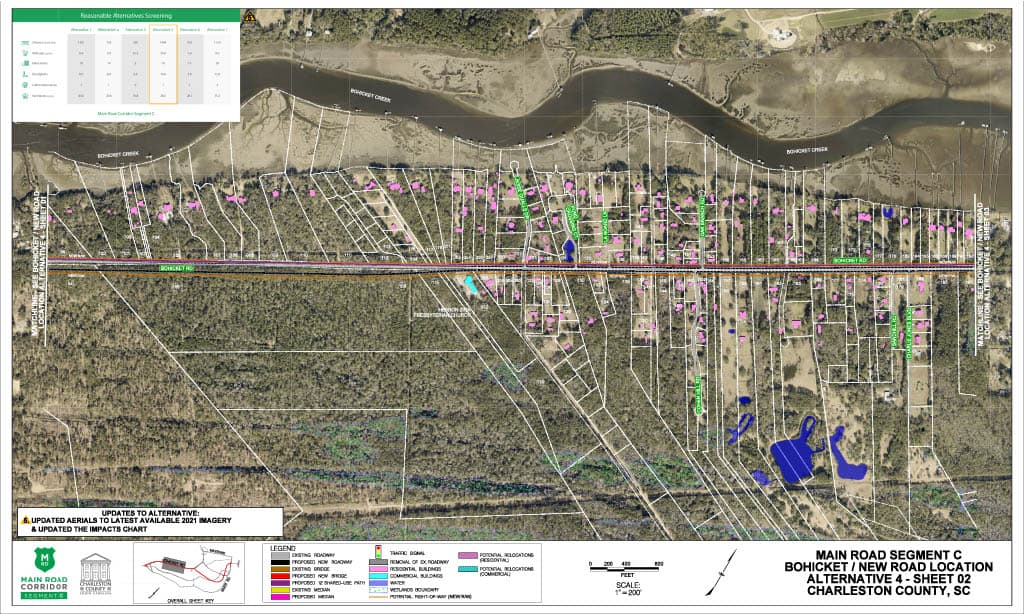
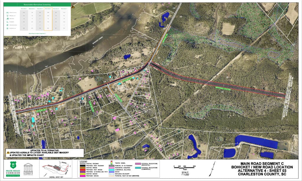
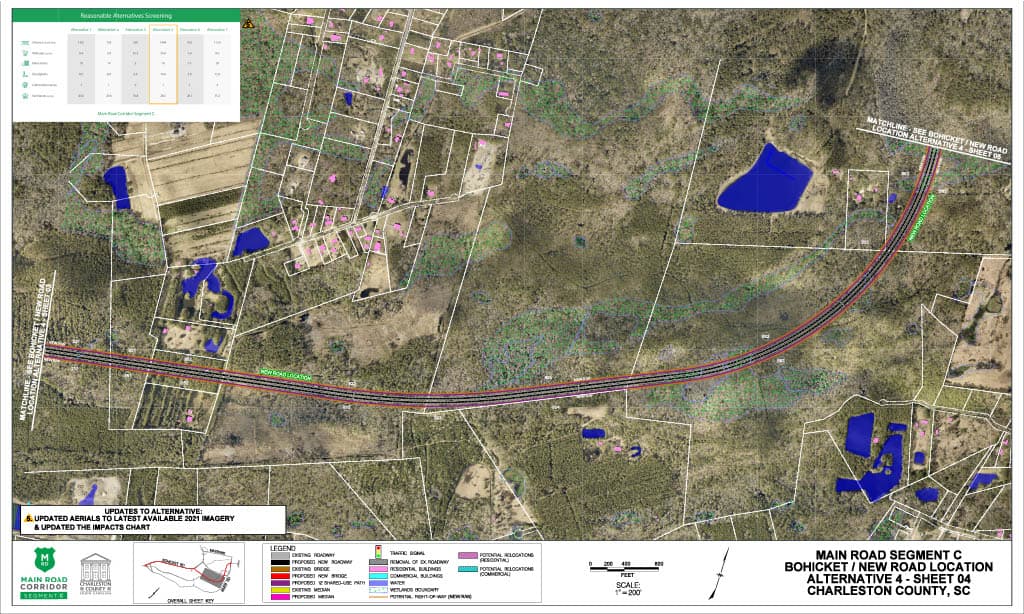
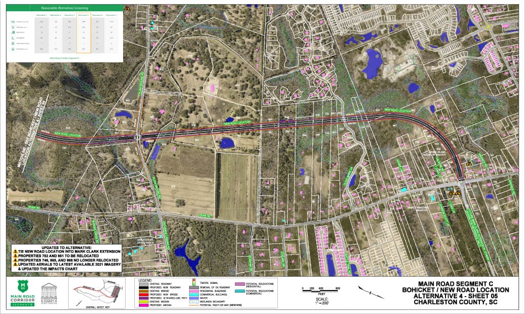
Alternative 4
Bohicket Road and New Road Location ($170-$200 M)
Alternative 4 KMZ
This KMZ file works in the program Google Earth, and will allow you to view the entire alternative. The KMZ file is a more interactive option to viewing the alternatives. However, this option will not show the matrix comparing the alternatives or a legend.
DownloadWetland Impacts
Land permanently or seasonally covered with water is called a wetland. Wetlands are considered “waters of the United States” and are regulated under the Clean Water Act. The project team must identify all wetlands within the project area and avoid impacting them if possible. If an alternative meets the purpose of the project but cannot avoid impacts to a wetland, the County is required to minimize and mitigate impacts.
34 acres
Stream Impacts
Streams are considered “waters of the United States” and are regulated under the Clean Water Act. The project team must identify all streams within the project area and avoid them if possible. If an alternative meets the purpose of the project but cannot avoid impacts to streams, the County is required to minimize and mitigate impacts.
1484 linear feet
Potential Relocations
These are properties that may require relocation of the residence or business in order to construct the project. The project team must identify all potential property relocations within the project area and avoid them if possible. If an alternative meets the purpose of the project but cannot avoid property relocations, the County is required to follow the United States Uniform Relocation Assistance and Real Property Acquisition Policies Act of 1970, the South Carolina Eminent Domain Procedure Act, and SCDOT’s Right of Way Manuals.
16
Floodplain Impacts
Floodplains are areas next to streams or rivers which experience flooding when the water is high. The project team must comply with Executive Order 11988 and document efforts to avoid, minimize, and mitigate impacts to floodplains.
14.6 acres
Farmlands
Farmlands of statewide importance fall under the Farmland Protection Policy Act. These are farmlands that meet specific criteria based on the physical and chemical properties of the soils. Farmlands of statewide importance are identified by the Soil Conservation Service, and impacts must be documented in the environmental documentation.
of Statewide Significance
57.2 acres
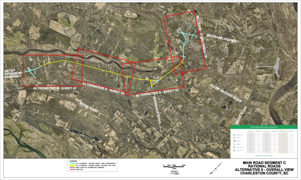
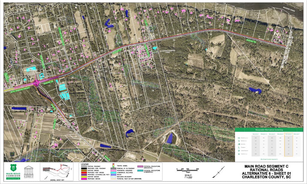
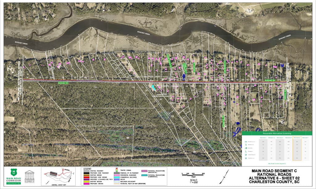
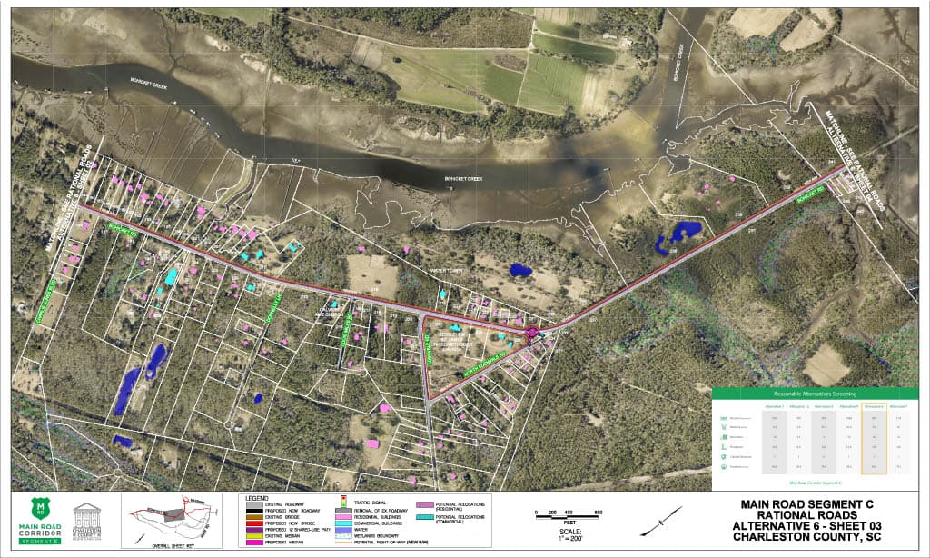
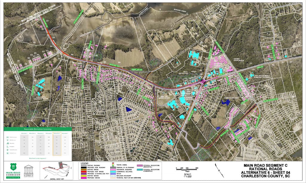
Alternative 6
Rational Roads ($40-$50 M)
*This is based on an alternative by Rational Roads; their concept can be found at https://rationalroads.org/
Alternative 6 KMZ
This KMZ file works in the program Google Earth, and will allow you to view the entire alternative. The KMZ file is a more interactive option to viewing the alternatives. However, this option will not show the matrix comparing the alternatives or a legend.
DownloadWetland Impacts
Land permanently or seasonally covered with water is called a wetland. Wetlands are considered “waters of the United States” and are regulated under the Clean Water Act. The project team must identify all wetlands within the project area and avoid impacting them if possible. If an alternative meets the purpose of the project but cannot avoid impacts to a wetland, the County is required to minimize and mitigate impacts.
6.5 acres
Stream Impacts
Streams are considered “waters of the United States” and are regulated under the Clean Water Act. The project team must identify all streams within the project area and avoid them if possible. If an alternative meets the purpose of the project but cannot avoid impacts to streams, the County is required to minimize and mitigate impacts.
935 linear feet
Potential Relocations
These are properties that may require relocation of the residence or business in order to construct the project. The project team must identify all potential property relocations within the project area and avoid them if possible. If an alternative meets the purpose of the project but cannot avoid property relocations, the County is required to follow the United States Uniform Relocation Assistance and Real Property Acquisition Policies Act of 1970, the South Carolina Eminent Domain Procedure Act, and SCDOT’s Right of Way Manuals.
16
Floodplain Impacts
Floodplains are areas next to streams or rivers which experience flooding when the water is high. The project team must comply with Executive Order 11988 and document efforts to avoid, minimize, and mitigate impacts to floodplains.
5.3 acres
Farmlands
Farmlands of statewide importance fall under the Farmland Protection Policy Act. These are farmlands that meet specific criteria based on the physical and chemical properties of the soils. Farmlands of statewide importance are identified by the Soil Conservation Service, and impacts must be documented in the environmental documentation.
of Statewide Significance
34.6 acres
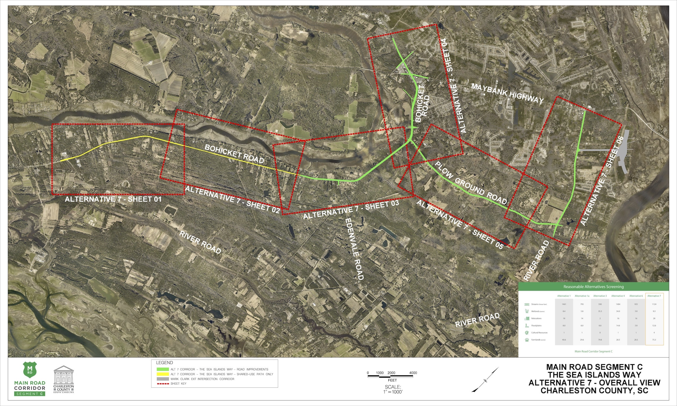
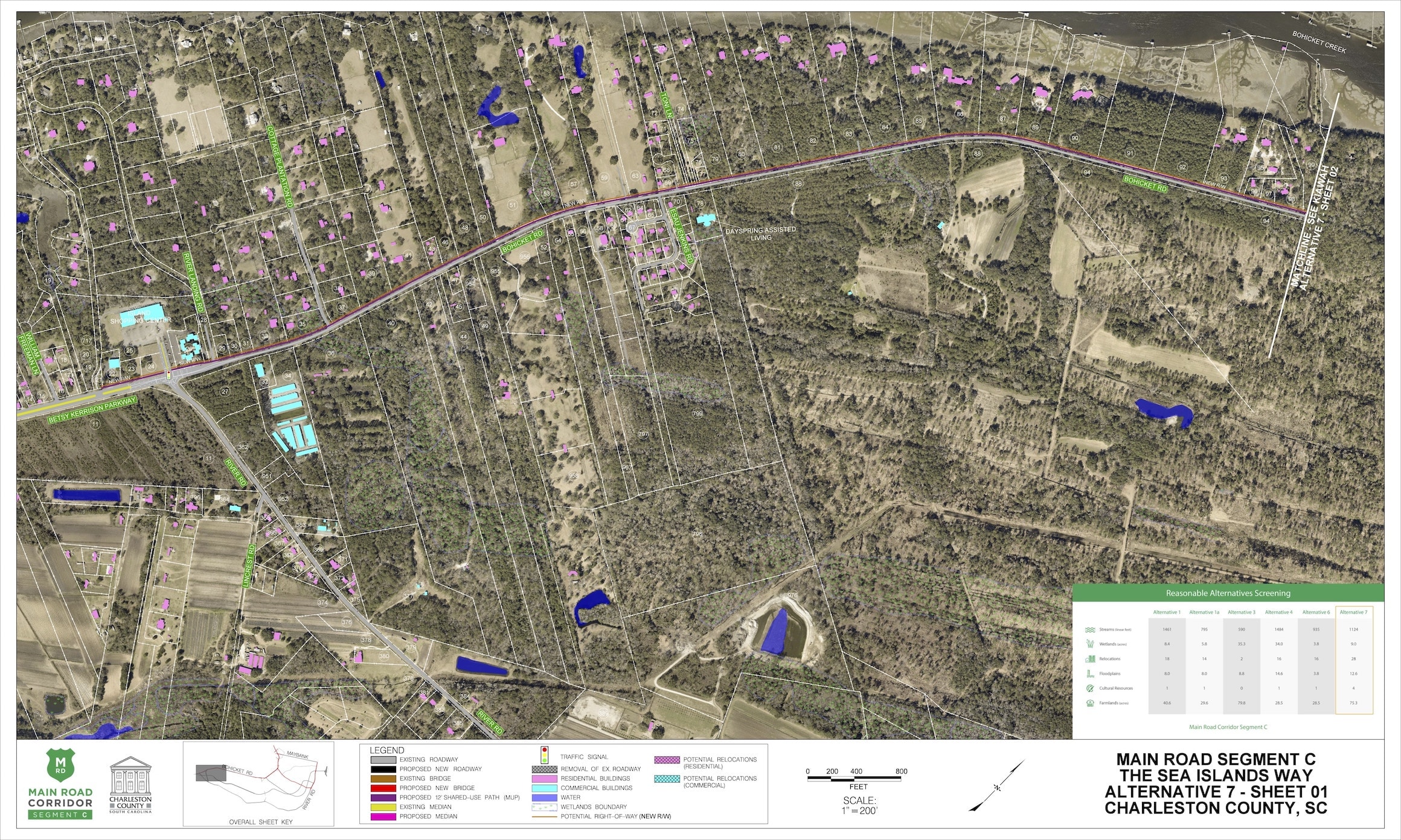
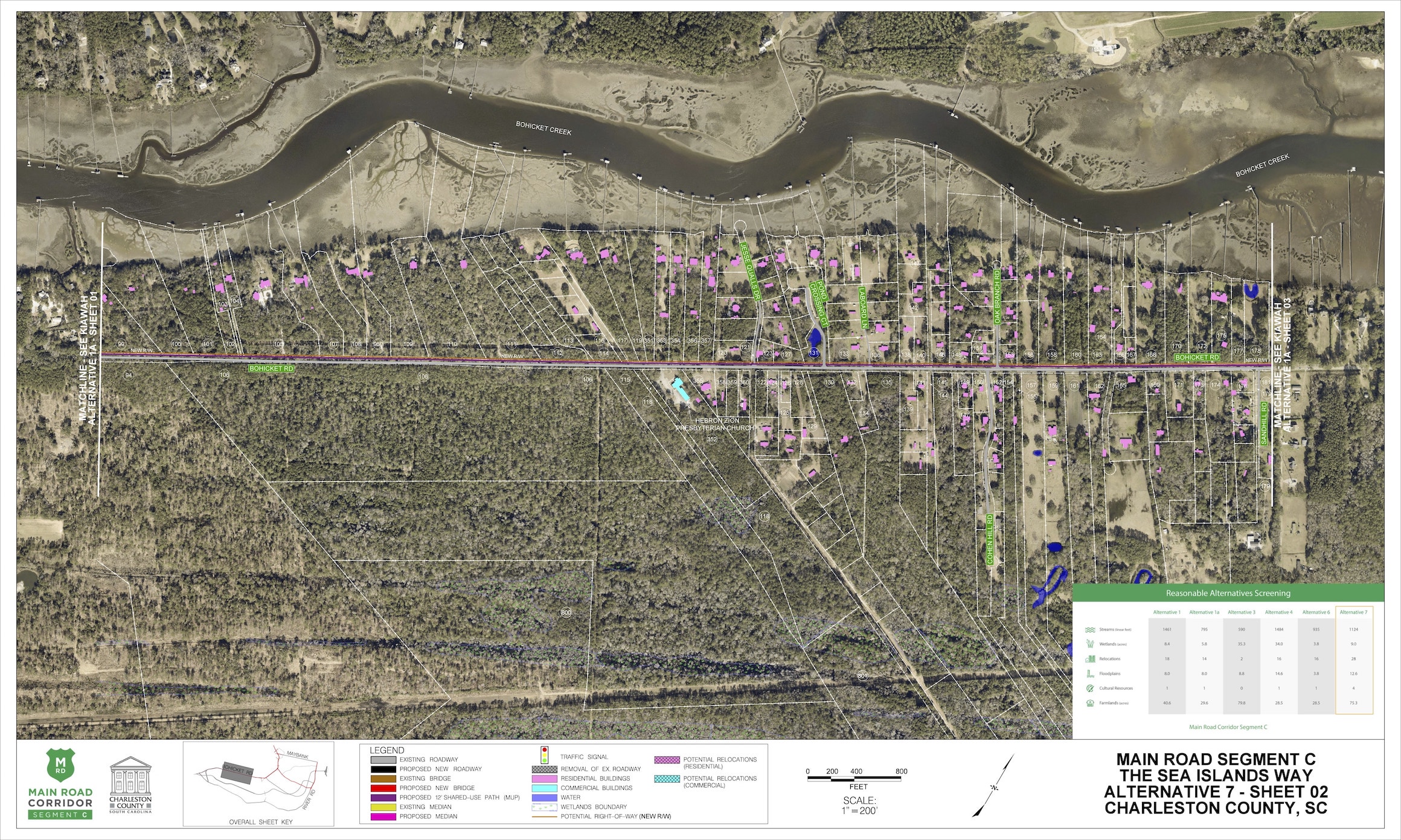
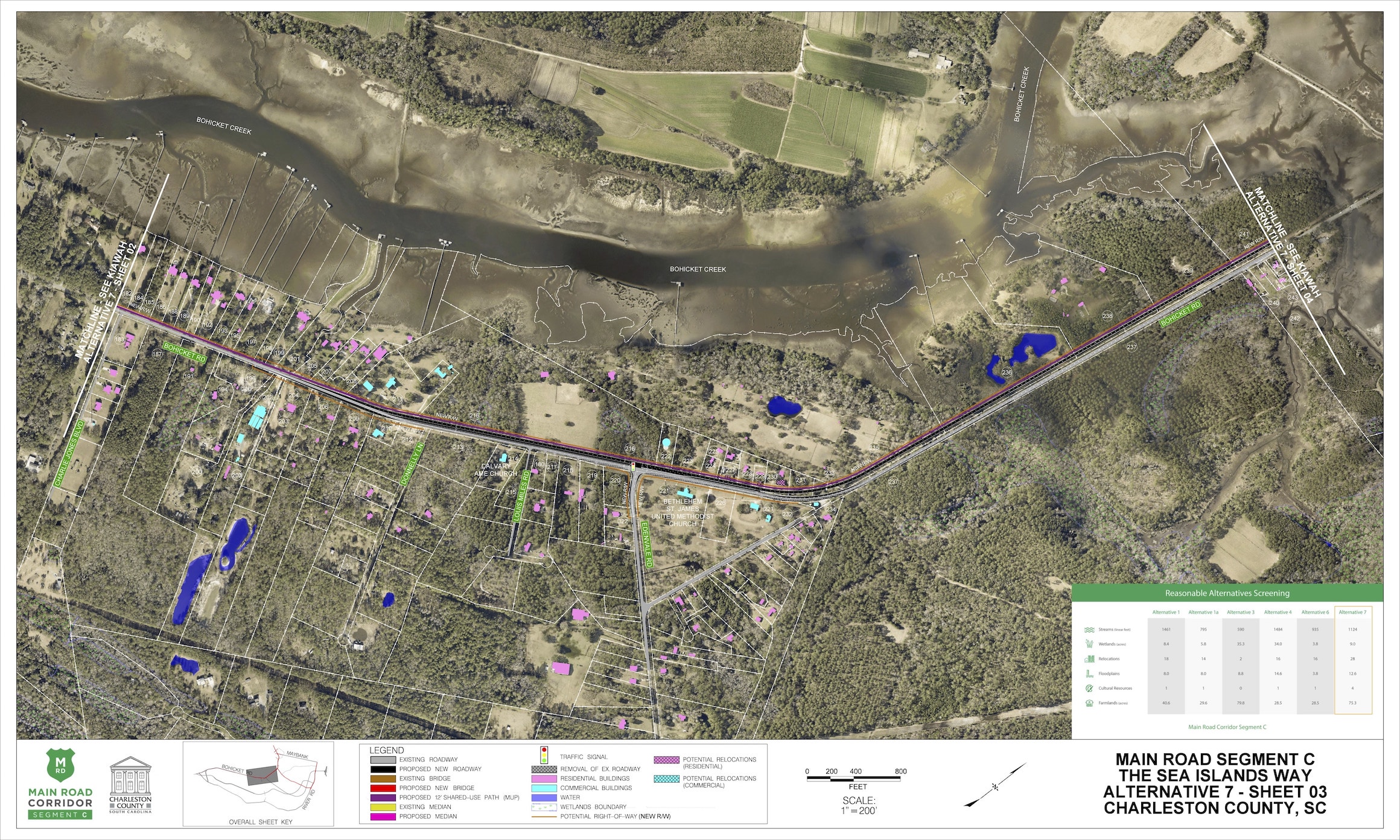
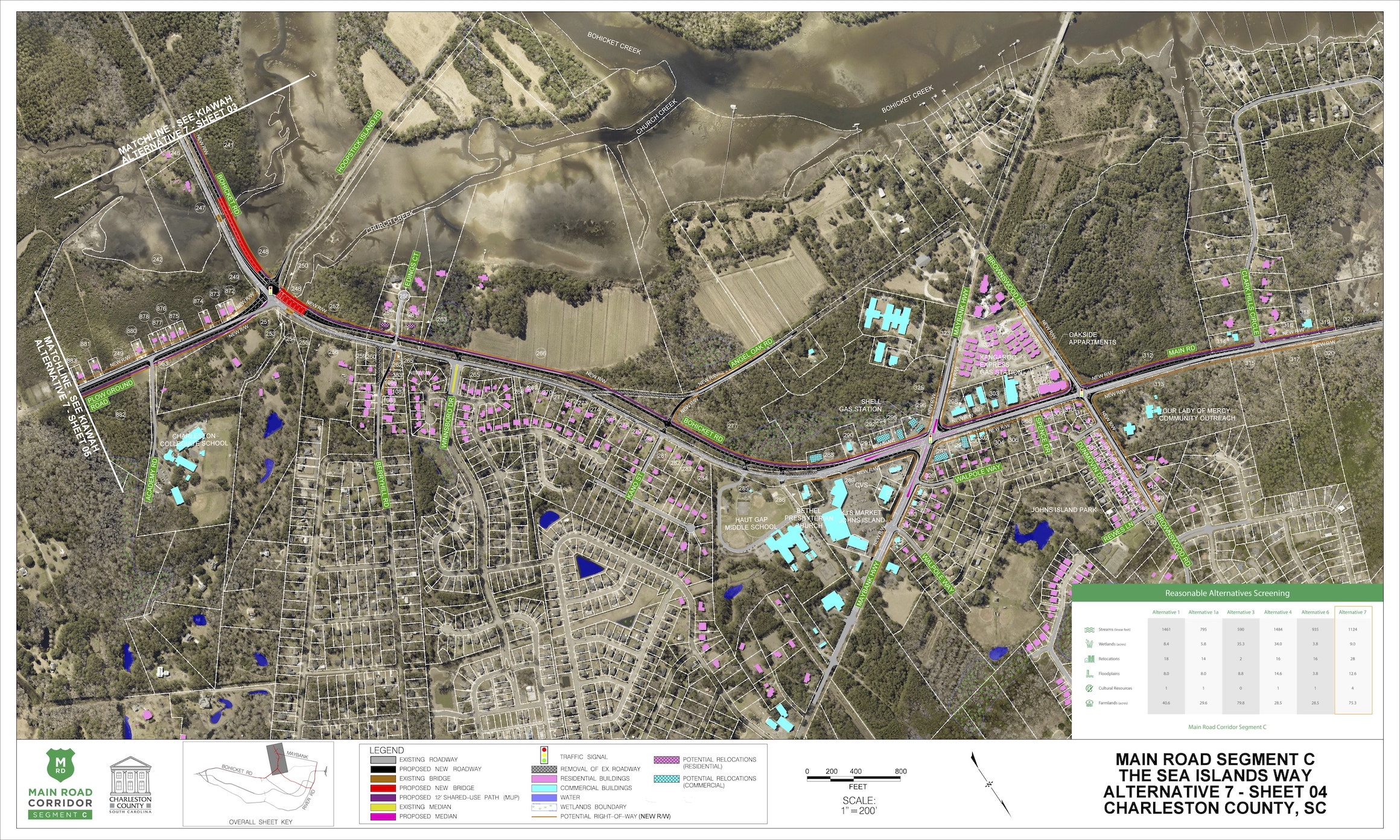
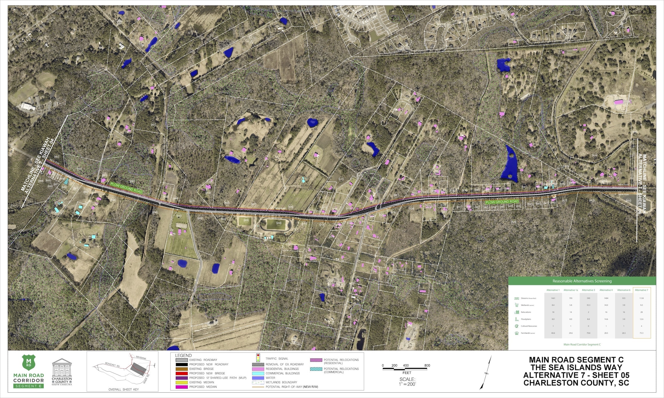
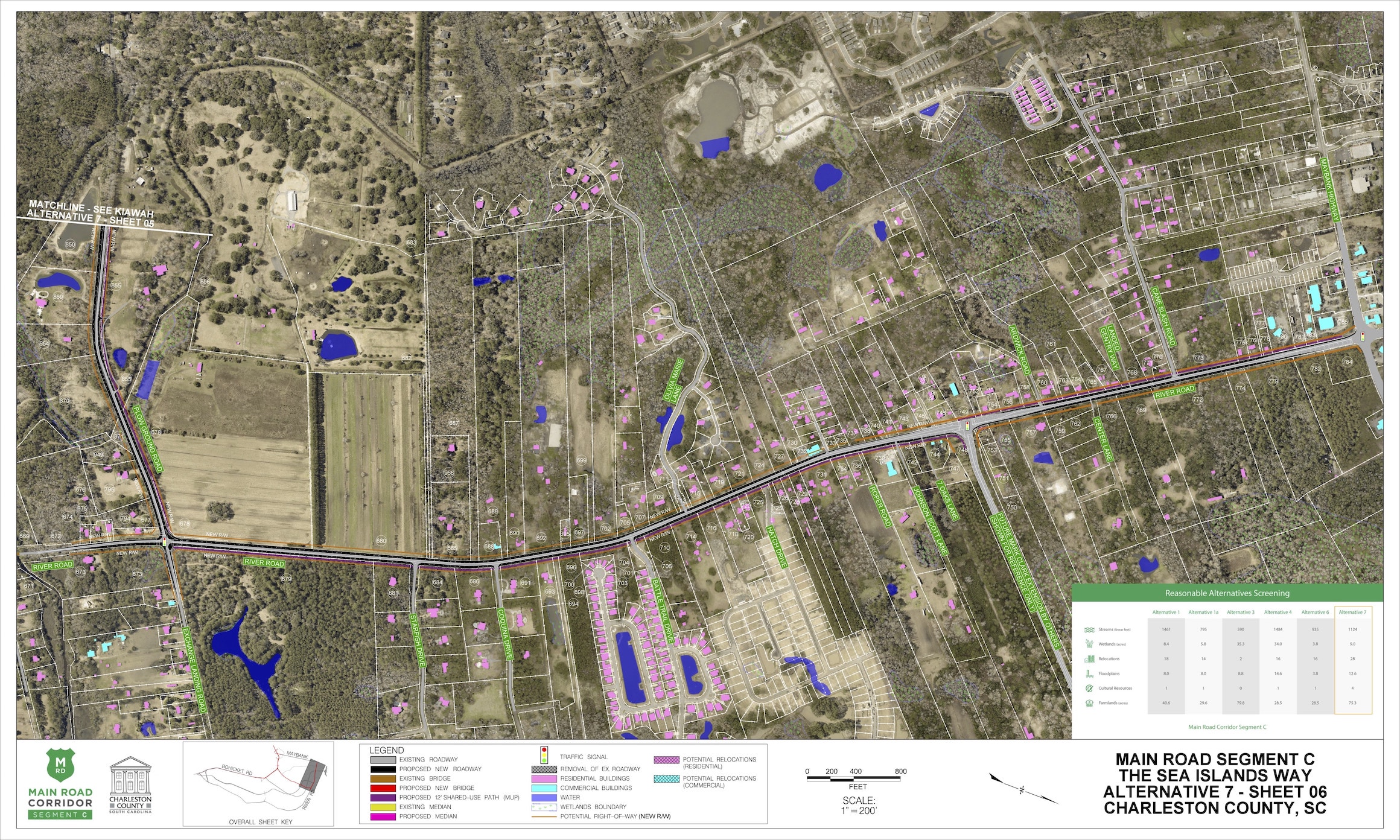
Alternative 7
The Sea Islands Way ($135-$155M)
Alternative 7 KMZ
This KMZ file works in the program Google Earth, and will allow you to view the entire alternative. The KMZ file is a more interactive option to viewing the alternatives. However, this option will not show the matrix comparing the alternatives or a legend.
DownloadWetland Impacts
Land permanently or seasonally covered with water is called a wetland. Wetlands are considered “waters of the United States” and are regulated under the Clean Water Act. The project team must identify all wetlands within the project area and avoid impacting them if possible. If an alternative meets the purpose of the project but cannot avoid impacts to a wetland, the County is required to minimize and mitigate impacts.
9 acres
Stream Impacts
Streams are considered “waters of the United States” and are regulated under the Clean Water Act. The project team must identify all streams within the project area and avoid them if possible. If an alternative meets the purpose of the project but cannot avoid impacts to streams, the County is required to minimize and mitigate impacts.
1124 linear feet
Potential Relocations
These are properties that may require relocation of the residence or business in order to construct the project. The project team must identify all potential property relocations within the project area and avoid them if possible. If an alternative meets the purpose of the project but cannot avoid property relocations, the County is required to follow the United States Uniform Relocation Assistance and Real Property Acquisition Policies Act of 1970, the South Carolina Eminent Domain Procedure Act, and SCDOT’s Right of Way Manuals.
28
Floodplain Impacts
Floodplains are areas next to streams or rivers which experience flooding when the water is high. The project team must comply with Executive Order 11988 and document efforts to avoid, minimize, and mitigate impacts to floodplains.
12.6 acres
Farmlands
Farmlands of statewide importance fall under the Farmland Protection Policy Act. These are farmlands that meet specific criteria based on the physical and chemical properties of the soils. Farmlands of statewide importance are identified by the Soil Conservation Service, and impacts must be documented in the environmental documentation.
of Statewide Significance
75.3 acres